Categories
TVGO Applications

Railway Construction Surveying: How LiDAR, Mobile Mapping and GNSS Improve Corridor Projects

A practical look at surveying services for construction contractors, with a particular focus on major railway corridor projects

This article was featured in the August 2026 issue of the German Surveying VDV Magazine, written by Kossert, the Surveying Project Manager at Spitzke, a customer of GeoCue.

By Guido Kossert

On major corridor projects, it’s not only the volume of construction work that grows with the size and complexity of the project. The supporting services around that work grow as well. Surveying is a perfect example. It plays an important role before construction begins, throughout the work itself, and again at the completion of the project. Simultaneously, surveying teams are being asked to do more with tighter schedules and with fewer available specialists. New and more efficient technologies are helping close that gap. This article looks at several typical surveying applications in railway infrastructure construction.

How LiDAR and Other Technologies Are Changing Construction Surveying

On most construction projects, the contractor is responsible for carrying out or commissioning surveying services in addition to the construction work itself. That includes collecting supplemental data before work begins, supporting construction planning, providing data for machine control, establishing the design track position, and setting out a wide range of construction activities, particularly in civil engineering. Surveying is also required to confirm that the completed work matches the original design plans.

Depending on the size and complexity of the project, the need for up-to-date surveying data can be significant. Because much of this work takes place before construction begins, during breaks in activity, or after other phases are complete, it often goes unnoticed when a project is evaluated. Even so, it plays a critical role in construction accuracy and can have a significant impact on both scheduling and budget.

Staffing is an important part of that challenge. In the past, a larger surveying workload could often be handled simply by assigning more people. Today, qualified personnel are harder to find, so technology has become increasingly important. Systems such as LiDAR allow teams to collect far more data with fewer people and in less time.

These technologies also create opportunities that extend beyond the traditional measurement of site conditions. They can support areas such as material logistics, project documentation, and construction planning. At the same time, larger datasets shift more of the workload from the field to the office. Processing can require substantial computing power, storage capacity, and reliable methods for transferring data. On large projects, datasets can quickly reach the terabyte range. Sensor technology is becoming more accessible, but it still represents a meaningful investment and must be planned accordingly.

Figure 1: Hamburg to Berlin corridor rehabilitation. Numerous structures, especially in station areas, create a high demand for surveying data.
DJI Drone
Figure 2: DJI M300 RTK drone equipped with a TrueView LiDAR system for aerial data capture.

Source for all figures: Spitzke SE.

Contractors typically receive surveying data from the client, often as part of the overall design plan. The information may come from the client’s own records or from outside service providers. For major projects, DB InfraGO (the public-interest infrastructure subsidiary of Deutsche Bahn responsible for managing and operating Germany’s rail network and passenger stations) also frequently provides aerial survey data through its X2BIM platform. Even with these resources, a rail network of roughly 39,000 kilometers presents obvious challenges.

Existing records can vary widely, especially when they were created at different times or with different coordinate systems. Newer railway infrastructure data are generally based on the DB_REF 2016 standard, which replaced DB_REF 2003. In some areas, older Gauss Kruger data can still be found, and parts of former East Germany may contain records based on Krassowski ellipsoid projections. Because these systems do not align directly, corrections and careful checks may be required.

Older secondary lines can present another challenge. As-built information may be incomplete or missing altogether. Even when data exists, site conditions may have changed because of natural ground movement, reconstruction, or events such as the 2021 flooding. Corridor projects add another layer of complexity because the area being surveyed can be so large that months, and sometimes years, may separate the newest and oldest datasets by the time all information has been reviewed, collected, and processed.

That becomes especially important in locations where tight tolerances must be maintained, such as machine-controlled construction or station areas with specific clearance requirements. As a result, supplemental surveying before construction can vary greatly from one project to another.

Even when the starting data is good, additional measurements may be needed to answer specific planning questions. Potential conflicts may be identified during design, or the available cross sections may not be detailed enough to accurately represent the track geometry. On the Nuremberg-to-Regensburg corridor, for example, a planned realignment from the no-longer-permitted 3.5-meter track spacing to the 4.5-meter spacing required for new construction meant that fixed constraints, including bridges and mast locations, had to be evaluated very carefully.

The way surveying is organized depends on the task, the local environment, and how accessible the line is while it remains in service. Safety always comes first. On the Hamburg to Berlin corridor, where Spitzke worked with Leonhard Weiss on Lot 2, surveying in Spitzke’s assigned sections began more than six months before the main construction phase. One reason was the time required to process the newly collected data and compare it with the design and existing condition data. The Right Rhine corridor rehabilitation, which entered construction in July 2026, also required extensive advance surveying, although the amount varied by location.

User with TV GO
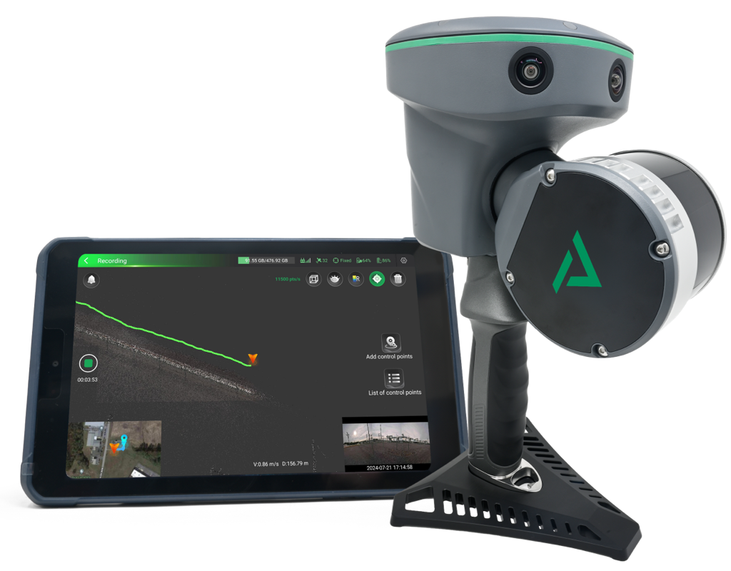
Figure 3: Wearable LiDAR system, TrueView GO, with interface and ergonomic carrying support.
Figure 4: On the Nuremberg to Regensburg corridor, some overhead line mast locations were so difficult to access that foundation pipes, masts, and box foundations had to be flown into position.

For an as-built survey or an update to existing datasets, a survey using a mobile mapping system, or MMS, can be an efficient option. On the DB InfraGO network, Trimble’s MX9 is approved for track surveying in accordance with Ril 883 [2]. Mobile mapping systems are typically built as multisensor platforms that combine LiDAR, cameras, GNSS, and an inertial measurement unit, or IMU. By combining these technologies, the position of LiDAR measurements can be determined accurately even in tunnels or other obstructed environments.

The IMU does require a minimum speed to produce reliable trajectory data. In general, the vehicle should travel above 40 kilometers per hour, although newer systems can provide good results at around 20 kilometers per hour. Stops should still be avoided because the measurement process may need to be reinitialized. That makes long distance MMS surveying more difficult during active construction, when tracks are occupied by construction operations and frequent stops are likely.

A mobile GEDO IMS system provides another option. Because it combines a track measurement trolley with IMU sensors, it is not dependent on continuous travel at a constant speed. Across the three corridor projects discussed here, both the MX9 and GEDO IMS systems were successfully used by Gi Consult as a subcontractor, or surveys were completed before the lines were returned to service.

MMS can capture a detailed picture of the track position and the environment around it in a relatively short amount of time. Minimum speed requirements can reduce resolution in some areas, so additional detailed measurements may still be necessary. Even so, surveying roughly 100 kilometers of track with MMS can often be completed in less than a day. As with many modern surveying methods, much of the total effort comes later during processing.

Where overflight approval is available, a drone equipped with LiDAR can also collect data while the railway remains in operation. This approach is especially useful in difficult to access areas because high point cloud densities can be achieved without requiring the operator to enter the track or danger zone.

Point cloud visualization
Figure 5: Visualization of restricted clearance measurements in station and signal areas.

Slopes often combine several difficult conditions. Track sections may not be safely accessible from the outside, and the slopes themselves can be affected by geological movement or erosion. That means the survey may need to capture not only the track position, but also the full slope surface.

This may be necessary to plan a realignment or, as on the Right Rhine corridor, to support extensive slope stabilization work. In those situations, current survey data is needed for both design and setting out. An MMS survey run or drone flight can provide the base dataset. If more detail is required, the information can then be supplemented on a closed track using a rail mounted system or a handheld LiDAR scanner such as the system shown in Figure 3.

At first glance, checking a construction area for unexploded ordnance may seem unrelated to surveying. In practice, surveying can be essential, especially for railway electrification or overhead line renewal projects that require deep excavation.

On large corridor projects, it would be impractical to survey the entire track area for ordnance. A more efficient approach is to focus on the locations where earthwork will take place, such as future overhead line mast positions. Those locations must therefore be identified and set out in advance.

On the Nuremberg to Regensburg corridor, this work began almost a year before construction. Millimeter level accuracy was not necessary for the initial guidance of ordnance detection teams because the detection process itself includes a substantial safety buffer. That allowed the surveying method to be selected based on the local conditions and the most efficient workflow.

For most of the work, RTK rovers were used. With GNSS, they achieved an accuracy of about plus or minus 2 to 3 centimeters. Using two rovers, the team set out 1,180 overhead line mast locations in approximately two weeks. A conventional total station approach would have taken at least twice as long.

Surveying remains critical throughout active construction. A large share of the work involves setting out planned construction activities, especially civil engineering work in areas where precise survey data is critical.

Another major task is documenting completed work for the client. This includes design versus as-built comparisons and, where necessary, documentation that supports change orders. The methods used can cover nearly the full range of approved surveying technologies, depending on the site conditions and the level of accuracy required.

Documenting restricted clearance locations is one of the most important tasks during or after construction. Modern surveying technologies can also support construction directly, including logistics and material planning.

On existing lines, most relevant restricted clearance locations are already known and are included in the information provided by the client. These locations are commonly found around bridges, signals, tunnels, and especially in station areas.

After construction, the affected locations must be measured again to confirm that safe railway operations remain possible. Any new restrictions created by the work must also be added to the final as-built records.

On open track, point specific measurements are often sufficient because potential conflicts can usually be ruled out visually or are limited to short sections. Station areas are different. Infrastructure is much more concentrated, so construction work and final conditions need to be monitored and documented with much greater care.

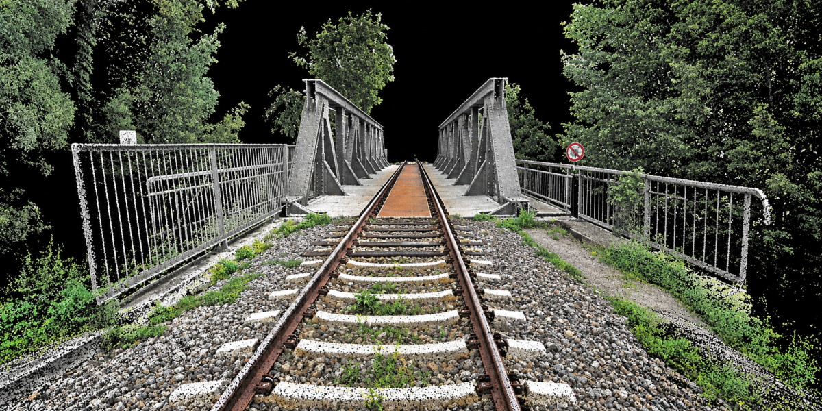
Railway pointcloud
Figure 6: Point cloud representation of a railway overpass on the Neustadt Glewe to Parchim project, captured with a handheld LiDAR scanner.

Large construction projects move large amounts of material, and transportation capacity needs to be planned as accurately as possible. This applies to sleepers, rails, ballast, and often significant quantities of earth.

On the Neustadt Glewe to Parchim project, which was carried out in parallel with the Hamburg to Berlin corridor work, extensive construction was planned along the trackside paths and the railway embankment. Site conditions and vegetation had changed enough that the available design data and photographic records no longer provided a reliable basis for estimating earthwork volumes.

LiDAR provided a practical solution. During an existing corridor closure, approximately 16 kilometers of the affected section were walked and scanned from both sides in a single day using the TrueView GO handheld LiDAR scanners. The resulting data made it possible to classify vegetation and other elements that could distort the calculation, then determine the volume of earth that needed to be removed or placed.

With that information, transportation could be planned more accurately and resources could be used more efficiently. The same approach can be used for material stockpiles on staging areas. The TrueView GO 116S scanner can often measure a stockpile faster and more accurately than counting truckloads or relying on simplified geometric assumptions.

The workflow is straightforward. The operator walks around the stockpile with the scanner, and the captured data are then processed in software to calculate volume.

Stockpile TV GO
Figure 7: LiDAR capture of a stockpile on a storage area on the Hamburg to Berlin project.

The examples in this article are not intended to cover every possible use of construction surveying. They do, however, show how well-planned surveying services can support major projects when teams have the right technology and enough time to use it effectively.

New technologies continue to expand what’s possible. They allow teams to collect more data, target that data more precisely, and complete the work in less time. They can also reduce disruption to railway operations by limiting the need for track closures and improve safety by keeping personnel out of difficult or hazardous areas.

The key is to recognize surveying as an essential part of project delivery, not simply as a supporting task. The industry also needs to continue attracting young professionals to railway infrastructure surveying. That includes recognizing the value of new technologies and creating approval and certification processes that allow those tools to be used effectively.

Sources

[1] Bauer, F.; Sauer, C.: Reconstruction of the Eifel line after flood damage, EI 03/2023, pp. 44 to 48.

[2] Ramann, J.; Sinning, A.; Wegner, V.: Introduction of Mobile Mapping for Track Surveying, EI 04/2023, pp. 19 to 24.

Author
Guido Kossert
Surveying Engineer
Spitzke SE, Grossbeeren
Categories
TVGO Applications

TrueView GO Brings Faster, Smarter LiDAR Surveying to Complex Construction Projects

For today’s construction teams, fast and accurate site documentation is no longer a nice-to-have. It is becoming a critical part of how projects are planned, measured, documented and delivered.

That is especially true in road construction and civil engineering, where job sites change quickly, access windows are limited and crews often need to capture accurate information while working around traffic, closures and tight project schedules.

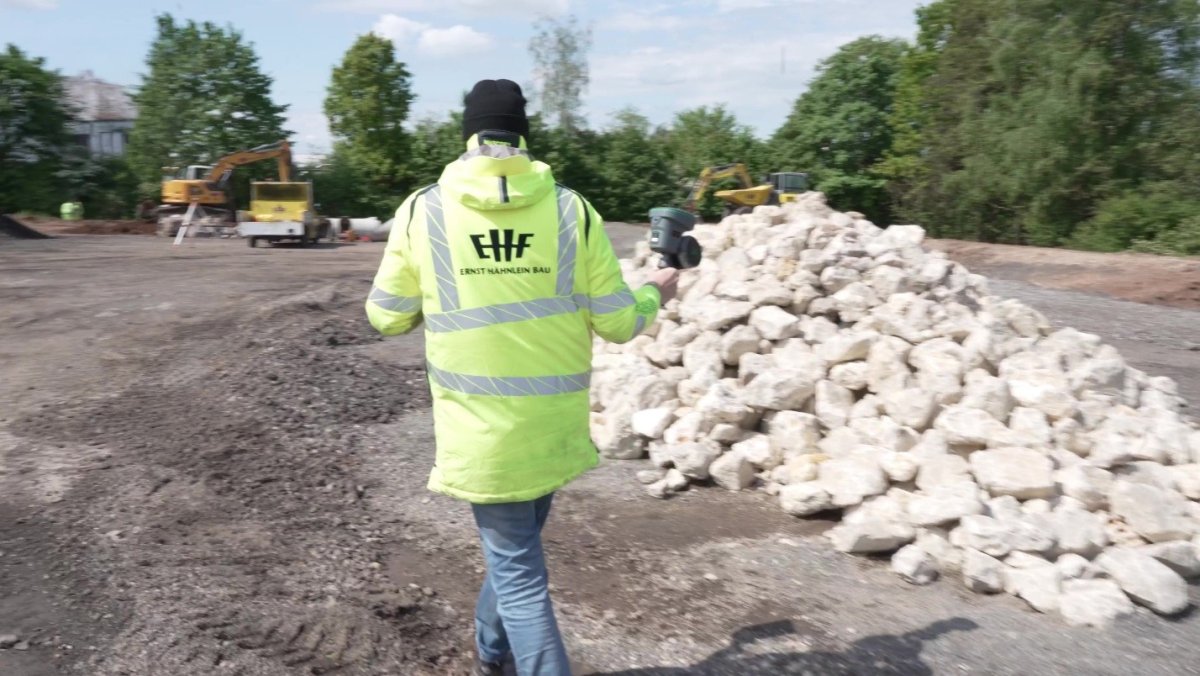
In a new testimonial video, Michael Begehold, Head of Surveying at Ernst Hähnlein Bau, explains how his team is using modern LiDAR technology, including handheld scanners and drones, to improve the way they collect and document construction data in the field.

Watch the video to hear directly from Michael Begehold and see how Ernst Hähnlein Bau is using TrueView GO and drone LiDAR technology to support modern road construction surveying and documentation.

Based in Feuchtwangen, Germany, Ernst Hähnlein Bau GmbH is a medium-sized, owner-managed construction company specializing in road construction, civil engineering, building construction and commercial construction. With more than 200 experienced employees, along with investments in asphalt plants, concrete plants, a central building materials laboratory and logistics, the company brings a practical, hands-on approach to modern construction.

That practical mindset is what led the surveying team to evaluate new technology in the field.

Begehold explains that his team regularly attends trade shows to see where surveying technology is headed. For him, the future is not about replacing good surveying practices. It is about being open to better tools, faster data collection methods and new ways to document what is happening on a construction site.

“I believe you should be open to technology, not just to different manufacturers, but also to new equipment and new methods of data collection,” Begehold says in the video.

Scanning construction site with Trueview Go handheld lidar scanner

That approach led the team to test the GeoCue TrueView GO on a road construction project that was originally planned for traditional surveying. The initial plan was to use a total station to collect individual point measurements, bring the data back to the office and then create the required documentation and analysis.

That workflow is reliable, but it can also be time consuming, especially when the project requires a larger area to be measured quickly.

With TrueView GO, the team was able to capture a much more complete picture of the construction site in less time. Instead of collecting one point at a time, the handheld LiDAR scanner captures a dense 3D point cloud while the operator moves through the site. The system combines LiDAR scanning, imaging and positioning, giving the team detailed surface information along with visual context.

For construction teams, that matters.

Setting up Trueview Go handheld lidar scanner to scan road material

When a road is open, milled, excavated or prepared for the next phase of work, the opportunity to document conditions may only exist for a short period of time. As Begehold explains, the information is available today, but once the work continues and the site changes, that information may be gone.

This is where TrueView GO fits so well into construction workflows. It is designed to help teams capture existing conditions quickly, safely and with the detail needed for documentation, measurement and analysis.

On the Ernst Hähnlein Bau project, one of the biggest challenges was traffic. The site was located on a heavily trafficked federal highway, with additional detour traffic routed through the area. The time between the road closure and the milling date was extremely tight.

Using the TrueView GO, the team was able to collect the data they needed while traffic continued to move. They did not need additional traffic regulations or permits. They were able to work from a safe area, maintain awareness of the traffic situation and still capture the points and locations needed for analysis.

The project also showed how different reality capture tools can work together. In the first phase, when the team had a full road closure and about 1.7 kilometers of open road, they used drone technology. The drone provided the accuracy needed for that phase, along with aerial imagery for documentation. In the second phase, where only a partial closure was available and traffic was still active, the team chose the handheld LiDAR scanner.

Man watching Drone scan construction site

That flexibility is one of the biggest advantages of using modern LiDAR on construction projects. A drone may be the right tool for one phase. A handheld scanner may be the right tool for another. Together, they give surveying teams more options for collecting the data they need based on site conditions, access, safety and project requirements.

TrueView GO is especially useful where traditional surveying can slow the process down. A base and rover workflow is excellent for collecting specific points, but it does not provide the same complete 3D documentation of the surrounding area. A terrestrial scanner can produce high-quality scans, but it often requires multiple setups, careful placement and more time on site.

With TrueView GO, the operator can quickly begin collecting data within minutes. The system is built for field use, with integrated LiDAR, cameras, GNSS and a dedicated field application for real-time visualization. For outdoor infrastructure projects, TrueView GO systems combine SLAM with multi-frequency GNSS, including RTK and PPK workflows, to improve accuracy and reduce the need for repeated loop closures during acquisition.

The result is a more efficient way to capture dense, colorized 3D data in real-world construction environments.

LP360 Lidar data processing software showing construction site

Back in the office, the data can be processed in LP360 Land, where teams can handle SLAM, RTK and PPK processing, point cloud colorization, QA/QC, editing, filtering, surface analysis, volume calculations, contours and other deliverables. This creates a complete workflow from field capture to final documentation.

For Ernst Hähnlein Bau, the value is clear. Modern LiDAR technology helps the team collect more information, faster, while improving safety and documentation. It also supports the growing need for construction companies to maintain accurate digital records of what was built, where it was built and what conditions existed during each phase of the project.

As construction moves toward more digital, BIM-ready workflows, the ability to quickly capture the real world becomes more important. TrueView GO gives surveying teams a practical way to do that without adding unnecessary complexity to the job site.

For companies like Ernst Hähnlein Bau, it is not just about adopting new technology. It is about using the right tool at the right time to make surveying faster, safer and more complete.

Categories
TVGO Applications

TrueView GO in Public Safety: Rapid Reality Capture for Safer Emergency Response

When it comes to emergency response at local schools, public safety professionals need more than paper floor plans and dated schematics. They need real-time, searchable digital maps that provide clear, actionable views of schools, hospitals, and municipal buildings, both indoors and out. The TrueView GO handheld LiDAR scanner by GeoCue is proving to be a game-changer in this space.

A recent deployment in Lafayette Parish, Louisiana, shows how the TrueView GO, paired with LP360 Land software, is helping emergency responders act faster and smarter, giving them critical visibility in the moments that matter most.

map of school rooms

For decades, school safety plans relied on static documents, floor plans tucked away in binders, known only to staff or local SROs. But when emergencies strike, those documents are no match for the coordination required between mutual aid agencies, many of whom have never stepped foot inside the building.

That vulnerability sparked action in Lafayette Parish, where officials partnered with Fenstermaker, a respected geospatial and engineering firm, to digitally map every public school campus, down to the door, and integrate those maps directly into the CAD systems of Lafayette 911. The goal: ensure that first responders, from any agency, could be routed not just to a building, but to a specific room, corridor, or entrance, with confidence.

At the heart of the project was the TrueView GO, GeoCue’s compact handheld scanner powered by SLAM (Simultaneous Localization and Mapping) and GNSS RTK/PPK fusion. It delivered precise, colorized 3D data in environments where GPS alone can’t operate, like stairwells, hallways, classrooms, and basements.

Scanning a school room with a TrueView Go LiDAR sensor

According to Coy LeBlanc, the project’s technical lead at Fenstermaker:

“We tested alternatives. When Mark Forsyth from NEI brought the TrueView GO by, it was super easy to use, so efficient. At that point we were like, yeah. No question. This is what we’re going to use.”

That ease of use made the difference. After just a half-day of training, the Fenstermaker team was scanning schools the very next day, completing three to four campuses per day, often in a matter of hours.

Operating during summer break to minimize disruption, crews swept through over 40 campuses in under 6 weeks. The process was fast but methodical:

  • Exterior and interior reference targets were set to strengthen georeferencing
  • Each classroom’s door ID was documented to standardize routing
  • 3D scans were processed in LP360 Land for QA/QC and cleaned output
  • Final deliverables were 2D indoor maps optimized for CAD integration and emergency dispatch workflows

The combination of SLAM-powered scanning and automated processing gave Fenstermaker the tools they needed to move at the speed of summer while delivering results that could save minutes, and lives, during an incident.

911 Call center viewing Classroom maps

While the RGB point cloud produced by TrueView GO was visually stunning, the final product needed to be more than a digital trophy. Fenstermaker built a pipeline to convert that 3D data into operational 2D indoor maps, with clean geometry, room IDs, corridor boundaries, door locations, and entrance names, standardized for multi-agency response and CAD compatibility.

These maps are now live in patrol cars, fire engines, and ambulances across Lafayette Parish, and they’re already helping responders navigate directly to the problem, instead of staging at the main entrance and guessing their way through a maze.

The success of the Lafayette project didn’t stop at schools. Other agencies are taking note, and for good reason. The same technology that enabled rapid mapping of public schools is now being evaluated for:

  • Hospitals and medical campuses
  • Courthouses and municipal buildings
  • Jails and correctional facilities
  • Libraries, event centers, and public transit hubs

Wherever GNSS fails and indoor complexity reigns, the TrueView GO excels. With real-time scanning, minimal training, and accurate results, it gives fire, police, EMS, and facility managers a fast and reliable tool to digitize their environments.

Ensures precision in indoor and GNSS-denied areas—perfect for hospitals, schools, and urban buildings.

View your scan as you walk using a dedicated tablet. Quickly verify coverage and identify gaps on the fly.

Three integrated 5MP cameras provide rich, RGB-colored point clouds—essential for QA, drafting, and visual confirmation.

No need to retrace your steps or walk in circles. Efficient scanning powered by onboard GNSS eliminates redundant data capture.

No cables, no external batteries, and no external computers. One device, fully integrated, built for mobility and ease-of-use.

School map point cloud in LP360 LiDAR Processing software

Every TrueView GO system comes with LP360 Land, a robust software suite built to handle SLAM-based handheld LiDAR processing with ease. Key features include:

  • Synchronized 2D, 3D, Profile, Street View Navigation, and Immersive views
  • Denoising, colorization, and classification
  • Automated QA/QC and error detection
  • Direct export to CAD, GIS, Revit, and more
  • Data fusion with mobile, aerial, and terrestrial sensors
  • Cloud-enabled workflows for collaboration

LP360 isn’t just an add-on. It’s a core differentiator that empowers public safety teams to go from scan to actionable map faster than ever before.

From legislative mandates to local initiatives, the demand for indoor reality capture in public safety is only growing. GeoCue’s TrueView GO offers a scalable, affordable, and easy-to-deploy solution that turns complex buildings into navigable digital twins, enabling faster emergency response, multi-agency coordination, and lifesaving clarity when every second counts.

Schools. Hospitals. Courthouses. Public Safety Centers.

Wherever accuracy meets urgency, TrueView GO is the right tool at the right time.

Categories
LiDAR Articles LiDAR News LiDAR Surveying & Mapping Software News TVGO Applications

GeoCue Introduces Immersive Image Explorer in LP360 for Next-Generation Data Fusion and Visualization

Step Inside Your Projects with Imagery Fused Seamlessly onto LiDAR Point Clouds

GeoCue, a global leader in LiDAR hardware and software solutions, proudly announces the release of the Immersive Image Explorer in LP360, a powerful new tool, available in LP360 Drone or LP360 Land Standard, that transforms how users interact with their geospatial data.

A screenshot of LP360 with the new Immersive Image Explorer. On the left the point cloud is enabled, and on the right is the 360° image overlaying the point cloud.

The Immersive Image Explorer fuses captured imagery with LiDAR point clouds, enabling professionals to virtually “walk through” their scanned environments inside LP360. Whether collected from aerial, mobile, or handheld TrueView systems, imagery can now be overlaid directly over the point clouds for a richer, more intuitive exploration experience, allowing 3D measurement directly on the images. The Immersive Image Explorer is also compatible with DJI L2 datasets.

“With the Immersive Image Explorer, our customers can step directly into their datasets, navigating captured environments as if they were on-site, while maintaining the accuracy and quality that LP360 is known for,” said Frank Darmayan, CEO of GeoCue. “It’s about bringing clarity, speed, and confidence to every project.”

Flexible Image Options

The Immersive Image Explorer supports both frame images imported directly from the integrated cameras on aerial, mobile, or handheld TrueView hardware, as well as fully 360° spherical images collected with the TrueView GO 360 Photo Kit or the FLIR LadyBug camera for mobile mapping. No matter which format is used, the Immersive Image Explorer gives you the ability to pan, scan, and evaluate your photos directly within LP360, ensuring every detail of your project can be examined with clarity and precision.

A screenshot of LP360 with the new Immersive Image Explorer on the right side of the screen, displaying an image captured with the TrueView GO aerial LiDAR sensor

A New Dimension in LP360 Visualization

The Immersive Image Explorer can be found within the Immersive View Window in LP360. The Immersive View Window is now the fourth main visualization option in LP360, joining Map View (2D), 3D View (isometric), and Profile View (cross-sectional).

Rather than replacing these views, the Immersive View Window complements them by combining many of their core capabilities into a single, intuitive interface. It allows users to view, navigate, and analyze their 3D data from multiple angles in real-time. Within this environment, the Immersive Image Explorer unlocks the ability to overlay imagery directly onto point clouds, seamlessly merging photos and LiDAR into a unified, immersive perspective.

Key Capabilities

Handheld Advantage – Merge imagery from TrueView GO’s three cameras with dense point clouds for detailed indoor and close-range visualization.

Aerial Integration – Seamlessly incorporate images from TrueView aerial payloads to provide context-rich overviews of larger sites.

Immersive Deliverables – Create a “street view” style navigation of your own data, fully measurable and directly inside LP360.

Flexible Image Sources – Works with frame images from integrated TrueView cameras or 360° spherical imagery captured by the TrueView GO 360 Photo Kit or FLIR LadyBug camera for mobile mapping.

Transforming Workflows Across Industries

From confined interior corridors to expansive construction sites, the Immersive Image Explorer empowers surveyors, AEC professionals, and public safety teams to work more effectively. By merging real-world imagery with LiDAR, inspection and validation workflows become faster and more accurate, giving teams a deeper understanding of their projects.

“The Immersive Image Explorer is more than a viewer; it’s a smarter way to navigate, validate, and present geospatial data,” added Vivien Heriard Dubreuil, CEO of mdGroup, GeoCue’s parent company. “By combining imagery and LiDAR in one immersive environment, we’re enabling professionals to work faster, communicate better, and deliver more value from their data to their clients.”

With Immersive Image Explorer, LP360 continues to evolve as the industry’s most complete platform for LiDAR and imagery workflows, putting users directly inside their data with clarity and precision.

Categories
LiDAR Articles LiDAR News LiDAR Surveying & Mapping Software News TVGO Applications

GeoCue Unveils Advanced Visualization Tools for LP360 at INTERGEO 2025

New 3D Modelling Mesh and Gaussian Splatting Add-Ons Expand the Power of TrueView GO and LP360

GeoCue, a global leader in geospatial hardware and software solutions, is excited to announce at INTERGEO, two major advancements for its LP360 software: the 3D Model Mesh Add-On and the Gaussian Splatting Add-On. These innovations bring new levels of visualization, realism, and deliverable quality to data collected with the TrueView GO.

Bringing LiDAR and Imagery Data to Life

With the 3D Modeling Mesh Add-On, users can now convert their LiDAR point clouds into high-quality, textured 3D mesh models. This delivers professional, shareable, and visually intuitive outputs ideal for client presentations, design reviews, and enhanced scene interpretation. The tool provides accurate mesh generation and streamlined post-processing.

TrueView GO handheld LiDAR scanner.

The TrueView GO handheld LiDAR sensor, available in the 116S and 132S models, gives professionals the freedom to scan complex indoor, outdoor, or underground environments with ease. By pairing TrueView GO with LP360 and these new add-ons, users can now go further than ever, producing 3D textured meshes for analysis and next-level Gaussian Splats for client-ready visualization.

The image above was captured with a TrueView GO and processed in LP360, to create a high-quality 3D mesh, turning point clouds into tangible models.

The Gaussian Splatting Add-On, designed for use with the TrueView GO’s 360 Photo Kit, introduces ultra photorealistic, immersive rendering to the LP360 ecosystem. Unlike traditional surface-based meshes, Gaussian Splatting produces immersive, life-like representations that give clients and project stakeholders a clearer understanding of real-world environments.

The image above, captured with a TrueView GO and brought to life as a Gaussian Splat, after processing the data in LP360,showcasing immersive detail straight from your point cloud.

“By integrating 3D Model Mesh and Gaussian Splatting directly into LP360, we’re empowering surveyors, engineers, and geospatial professionals to create richer deliverables, streamline workflows, and enhance collaboration,” said Frank Darmayan, COO of GeoCue Group. “LP360 continues to evolve to meet the needs of our users, delivering advanced processing and visualization tools that set a new benchmark for the industry.”

TrueView GO: Flexible Capture, Powerful Processing

The TrueView GO handheld LiDAR sensor, available in the 116S and 132S models, gives professionals the freedom to scan complex indoor, outdoor, or underground environments with ease. By pairing TrueView GO with LP360 and these new add-ons, users can now go further than ever, producing 3D textured meshes for analysis and next-level Gaussian Splats for client-ready visualization.

“LP360 is at the forefront of visualization technology,” said Vivien Heriard-Dubreuil, CEO of mdGroup, parent company of GeoCue. “With tools like Gaussian Splatting and 3D Model Mesh, our customers can extract the most value from their visual data and deliver powerful, real-world results. These advancements highlight GeoCue’s leadership in bringing cutting-edge research into practical, everyday workflows for the geospatial community.”

Availability & Live Demonstration Both add-ons will soon be available in LP360 and can be demonstrated live at INTERGEO 2025 in Frankfurt, Booth 12.1/G.054, where attendees can experience sample data sets and workflows firsthand.

Processing with the new add-ons requires a high-performance computer equipped with modern graphics capabilities, enabling users to fully experience the speed and realism of 3D meshes and Gaussian Splats.

Categories
LiDAR Articles LiDAR Events LiDAR News TVGO Applications

Discover the TrueView GO at E4 Chicago: The Must-Have Scanner for AV Professionals

Learn Why AV Professionals Choose TrueView GO for Fast, Accurate Room Scanning

GeoCue is proud to announce our first appearance at the E4 Experience in Chicago, where we’ll be showcasing our cutting-edge TrueView aerial and Handheld LiDAR solutions with Almo Pro AV, our newest GeoCue distribution partner. As the AV industry continues to embrace technologies that merge creativity with precision, tools like the TrueView GO are stepping forward as practical, cost-effective solutions for everyday design and installation challenges.

At this year’s E4, attendees will have the opportunity to see first-hand how TrueView GO, our handheld LiDAR + SLAM scanner, is transforming workflows for professional AV design, system integration, and production.

Why LiDAR Matters for Pro AV

In professional AV, the details of a space matter. Every rigging point, every wall angle, every ceiling truss and obstruction can influence the success of an installation. Designing audio coverage requires accurate room dimensions. Projection mapping depends on precise surface measurements. Even running cables through a venue can require knowledge of the pathways and infrastructure that aren’t always captured in paper drawings.

Traditionally, AV teams have relied on terrestrial laser scanners or total stations to capture this information. While these high-end systems can deliver sub-millimeter accuracy, they also come with significant trade-offs:

Cost: Terrestrial scanners can be prohibitively expensive, limiting access to only the largest firms or specialized survey teams.

Setup and workflow: Setting up tripods, moving equipment through a venue, and repeating scans across multiple positions takes time and interrupts the natural flow of a project site.

Specialized training: Operating and processing data from these systems often requires expertise outside the day-to-day skill set of AV professionals.

The TrueView GO offers an alternative that balances accuracy, mobility, and ease of use. With accuracies within a few centimeters and relative accuracies down to about one centimeter, the GO provides “surveying-grade” precision sufficient for AV applications,without the overhead of a traditional laser scanner. For most AV projects, where tolerances fall within inches rather than millimeters, this level of accuracy is exactly what’s needed.

TrueView GO in Action

The TrueView GO is a handheld LiDAR + SLAM scanner designed for mobility and speed. Instead of setting up a tripod or pulling a tape measure, you simply walk the room, scanning as you go. Its lightweight design and real-time visualization give you immediate feedback, so you can see whether you’ve captured the whole space before you leave the site.

Some of the most practical AV applications include:

  • Room and venue scanning: Capture complete floor-to-ceiling detail to design immersive sound systems, optimize projection coverage, or plan seating layouts.
  • Rigging and ceiling capture: Identify trusses, catwalks, and grid structures to coordinate lighting and projector placement.
  • As-built documentation: Deliver accurate models to architects, engineers, or clients to keep everyone aligned on existing conditions.
  • Installation verification: Rescan after installation to confirm that speaker arrays, lighting rigs, or projection surfaces were built to spec.

With its integrated imagery and colorization, the GO produces intuitive, photorealistic point clouds that are easy to navigate. Color helps identify doors, signage, cabling, and other features that may otherwise get lost in monochrome scans. And because the system relies on SLAM technology, you can scan even in environments with no GPS signal—basements, backstage areas, or inside large venues.

The LP360 Advantage

Collecting point cloud data is just the first step. The real value comes from processing, quality-checking, and delivering usable outputs that integrate into AV design workflows. That’s where LP360, GeoCue’s point cloud software, makes the difference.

With LP360 you can:

QA/QC your data immediately, ensuring coverage, accuracy, and completeness before moving on.

Register multiple scans seamlessly, aligning data sets into a single, coherent model.

Colorize and clean point clouds, remove noise, stray points, or move objects that can distract from the usable dataset.

Extract deliverables such as floor plans, elevations, and cross-sections that can be exported into CAD, Revit, Vectorworks, or other AV design platforms.

Create immersive deliverables for client review, giving stakeholders a visual, navigable 3D environment instead of just static measurements.

By pairing the TrueView GO with LP360, AV professionals can own the entire workflow—from capture to final deliverables—without outsourcing to third parties or investing in overly complex systems. This not only saves time and money but also gives you confidence in the accuracy of your work.

See It in Chicago

We invite you to join us at the E4 Experience in Chicago to see the TrueView GO in action. Chuck Snow from GeoCue will be at our booth to answer questions, demonstrate the scanner, and let you experience it for yourself. Pick it up, walk the room, and scan the floor. You’ll see just how easy it is to get “GOing” with handheld LiDAR.

Partnering with Almo Pro, GeoCue is committed to making advanced 3D scanning technology accessible to the AV industry. Whether you’re designing the next big immersive installation, fine-tuning audio coverage for a performance space, or documenting as-builts for collaboration, the TrueView GO and LP360 provide the precision, efficiency, and usability you need.

Come see us at E4 Chicago, and discover how we can help bring clarity and confidence to your next project.

Categories
TVGO Applications

The Ultimate Handheld Tool for Architectural Design and Reality Capture

In modern architecture, precision is everything. Whether you’re reimagining a historic structure, optimizing floor plans, or creating immersive 3D models, success starts with capturing reality: accurately, efficiently, and safely. That’s where TrueView GO, GeoCue’s cutting-edge handheld LiDAR + SLAM scanner, truly shines.

With the growing demand for digital twins, dynamic scanning, and reality capture workflows in the Architecture, Engineering, and Construction (AEC) space, the TrueView GO offers a unique approach to collecting spatial data. Let’s explore how this handheld scanner transforms architectural design, streamlines workflows, and differentiates itself from every other scanner in its class.

Blueprints

Take, for example, a project from Michael Liggett of Aerial Ethos. He was tasked with evaluating the feasibility of converting a challenging hillside crawlspace into a custom speakeasy and entertainment area. The space had:

  • Irregular geometry due to sloping topography and structural backfill.
  • Tight access with limited visibility.
  • Structural concerns that demanded accuracy without risk to the foundation.

Traditional tripod scanners or iPhone-based LiDAR were either too cumbersome or lacked precision. That’s where the TrueView GO handheld LiDAR system changed the game.

Crawlspace to be scanned

The TrueView GO is built for architectural complexity. Whether you’re mapping cramped crawlspaces, large atriums, underground parking garages, or stairwells, the hybrid SLAM + GNSS system ensures unmatched flexibility. You can walk freely, scan in real time, and visualize your point cloud instantly on the included tablet.

  • SLAM Technology: Perfect for indoor or GNSS-denied spaces. No satellite signal, no problem.
  • GNSS RTK/PPK: Use outdoors for higher global accuracy.
  • Loop-Free Path Planning: Forget walking in circles or retracing steps.

With three integrated 5MP cameras and powerful LiDAR sensors (Hesai XT-16 on the GO 116S, Hesai M2X on the GO 132S), you get rich colorized point clouds ready for reality capture, digital twin creation, and 3D visualization. Using LP360 Land, Architects can then export this data into popular platforms like SketchUp, Revit, or AutoCAD to begin modeling right away.

In Michael’s project, this meant:

  • Capturing every beam, joist, pipe, and HVAC duct.
  • Modeling cut/fill scenarios using Virtual Surveyor.
  • Visualizing multiple design options with SketchUp.

The result? A fully informed design process, fewer surprises, and faster client buy-in.

Cleaned crawlspace pointcloud

TrueView GO’s secret weapon is its sensor fusion, a combination of:

  • High-grade LiDAR for point cloud generation.
  • Precision GNSS (RTK/PPK) positioning when satellites are available.
  • Visual + inertial SLAM for seamless scanning without GNSS.

This allows architects to scan through complex spaces dynamically, without being constrained by traditional tripod setups. Use it for:

  • Interior scanning of multistory buildings
  • Renovation projects with tight access
  • Historic preservation efforts where mounting tripods could damage structures
  • Basement or sub-level scanning without light or satellite signals

Architects often work in time-sensitive environments. Whether scanning a site before construction begins or documenting a change order in the field, the TrueView GO provides real-time point cloud visualization through its dedicated tablet and app. This live feedback ensures complete data coverage before leaving the job site, reducing the risk of missed areas and costly return visits. Unlike other systems, TrueView GO requires no laptops, external cables, or third-party cameras, making it a truly streamlined solution. With single-button operation and automatic file management, it’s intuitive and efficient. It’s the sensor that’s easy enough for team members of any skill level to use confidently.

Crawlspace contours and volume

Every TrueView GO comes bundled with LP360 Land, a professional-grade LiDAR and imagery processing suite designed for speed and accuracy. With LP360, you can:

  • Visualize point clouds in 2D, 3D, profile, and immersive views.
  • Perform QA/QC and classification.
  • Extract floor plans, volumes, contours, and structural analysis data.
  • Fuse handheld data with drone or terrestrial scans for complete digital twins.

This allows architecture firms to own the full workflow from field to finish—without depending on costly third-party services.

To demonstrate the versatility of the TrueView GO, Michael Ligget scanned a challenging crawlspace beneath a custom hillside home, where the client was considering converting the area into a speakeasy-style entertainment space. Using the TrueView GO handheld LiDAR scanner, he captured detailed spatial data to assess the crawlspace’s dimensions, sloped topography, and potential structural constraints—laying the groundwork for feasibility studies and design planning.

Scan

Michael captured the crawlspace with TrueView GO, leveraging the built-in GNSS + SLAM combo for accurate positioning.

Process

Data was processed in LP360, cleaned in CloudCompare, and exported to Virtual Surveyor and SketchUp.

Deliver

  • Created design iterations based on accurate terrain surfaces.
  • Conducted volume studies and cut/fill analysis.
  • Generated client-ready 3D visualizations.

This workflow took hours instead of days—empowering the client to move forward with confidence.

3d sketchup model of crawlspace

TrueView GO helps architecture and engineering firms avoid costly mistakes. With high-resolution point clouds and precise measurements, your team can:

  • Identify structural interferences before construction begins.
  • Plan MEP layouts with confidence.
  • Avoid unnecessary site visits with comprehensive data.
  • Reduce rework and improve coordination with subcontractors.

Whether you’re redesigning a school, retrofitting a hospital, or modeling a heritage structure, TrueView GO lets you make smart design decisions faster.

TrueView GO doesn’t stop at handheld use. Accessory options make it adaptable to almost any architectural challenge:

Pole Mount: Safely scan above or below your reach. Ideal for attics, ceilings, or underfloor voids.

Suction Mount: Attach to vehicles like ATVs or golf carts to scan large exterior sites or access roads.

These tools increase the range and safety of your reality capture capabilities. Avoid ladders, scaffolding, or confined spaces.

Categories
LiDAR Articles LiDAR For Construction LiDAR For Engineering LiDAR For Utilities & Energy LiDAR Surveying & Mapping Software News TVGO Applications

Explore Your Data Like Never Before with the New Street View Navigation Mode in LP360

Enhance Your Reality Capture Workflow with the TrueView GO 360 Photo Kit

At GeoCue, we’re always looking for ways to make reality capture more intuitive, visual, and powerful. That’s why we’re excited to introduce the all-new Street View Navigation mode in LP360’s Immersive View, which supports the new TrueView GO 360 Photo Kit. When used in tandem, these powerful new tools enhance your handheld LiDAR workflow by integrating an Insta360 camera with LP360 Land’s 360° photo viewer, seamlessly merging spherical imagery with your point cloud for a true “street view” experience of your data. See for yourself in the video example below:

Whether you’re scanning a facility, capturing urban infrastructure, or building a digital twin of a complex site, Street View Navigation lets you walk through your dataset virtually, just like you would in a web-based street view tool. Only now, you’re viewing your own data, captured with the TrueView GO 360 Photo Kit and processed in LP360 Land.

TVGo 360 Capture Kit
The TrueView GO 360 Photo Kit with Insta360 mount (Insta360Cam not included)

What Is Street View Navigation?

Street View Navigation is a new tool in LP360’s Immersive View that allows users to intuitively explore images and point cloud data from a ground-level perspective. It enables you to move between image capture points, select a custom viewpoint, and see the scene from any direction with a simple click and drag.

This new feature is especially useful for datasets collected using SLAM-enabled sensors like the TrueView GO equipped with an Insta360 camera. The Street View Navigation will also work with TrueView Mobile Mapping Capable Sensors paired with the 360° Flir LadyBug Camera.

Now, with just a few clicks, you can jump into the dataset, pick a location on the map, and view your scanned environment from any angle. This feature is perfect for field teams, surveyors, AEC professionals, and public safety users who need quick, clear insight into captured spaces.

Seamless Integration with TrueView GO and LP360 Land

If you’re already using TrueView GO, the Street View Navigation feature will feel like second nature. It builds directly on the immersive visual power of the 360° image layer captured during your scan, allowing for a more natural, real-world understanding of the site.

This isn’t just about viewing, it’s about navigating your data in a smarter way. You no longer need to flip through individual images manually or jump back and forth in the point cloud to find what you’re looking for. Instead, LP360’s Immersive View now offers a smoother, more connected experience that supports faster data validation and clearer communication.

From confined interior spaces to long corridors and open job sites, the ability to “walk through” your dataset virtually saves time and improves confidence in the data, helping you ensure full coverage and spot missed areas before you even leave the job site.

How It Works: Pick Your View, Jump to It

Using Street View Navigation is simple. Inside the Immersive View, you’ll find a dedicated Street View Navigation button. Clicking it activates a set of tools specifically for navigating image stations.

The real magic happens with the Street View Picker tool. Once enabled, you can select a point on your map or image layer, drag in the direction you want to view, and LP360 will take you directly to that perspective. Whether you want to inspect a specific wall, look down a hallway, or explore a specific asset, it’s as easy as point, drag, and go.

With Street View Navigation, you can easily “walk-through” your scan.

You’ll also be able to move forward and backward through image stations, much like a street view application.

This kind of dynamic scanning visualization gives you complete situational awareness from a ground-level view, ideal for pre-construction documentation, forensic investigations, facility management, or any scenario where clarity and context matter.

Why It Matters: More Than Just a Viewer

Street View Navigation isn’t just another way to look at your data. This is a better way to use it.

By combining panoramic images with point cloud data and allowing seamless navigation between them, LP360 enables users to:

  • Enhance Reality Capture workflows by quickly validating areas of interest from a true-to-life perspective
  • Create and inspect Digital Twins with greater visual clarity and spatial understanding
  • Support SLAM data capture workflows, especially in complex or GPS-denied environments
  • Increase productivity by reducing time spent locating features or confirming site details
  • Improve communication with teams, stakeholders, and clients through more accessible visual context

And perhaps most importantly, this functionality is built directly into LP360 Land, so there’s no need for third-party viewers or extra software steps. Your imagery and point cloud data live together in one intuitive platform, with all the tools you need to measure and manage your projects more effectively.

With Street View Navigation you can seamlessly view the photo or point cloud

Visualize First. Decide Faster.

One of the biggest advantages of Street View Navigation is how fast and easy it makes decision-making. Need to confirm a dimension or assess the condition of a structure? Just jump to the viewpoint and look. Easily identify features in your point cloud, by viewing the image.

For many users, the ability to visualize features in context is just as important as raw measurement. Street View Navigation gives you both, allowing you to make informed decisions without second-guessing your data or flipping between tools.

Built for Your Workflow

Street View Navigation works seamlessly with LP360’s full ecosystem of tools. It’s ideal for:

  • AEC and construction professionals doing building documentation, pre-site planning, or as-built validation
  • Surveyors and engineers capturing data for corridor mapping, topography, and underground assets
  • Public safety and forensic teams documenting crash scenes or interiors
  • Facility managers conducting virtual inspections
  • Educators and researchers building visual references and interactive learning tools

If you rely on TrueView GO and LP360 for mobile or handheld mapping, this new mode will enhance your workflow and bring your dataset to life in 360°.

Ready to Navigate Smarter?

The Street View Navigation mode in LP360 represents a big leap forward in how we interact with spatial data. It’s fast, it’s simple, and it puts the power of immersive, visual understanding directly in your hands.

If you’re already using LP360 with TrueView GO, this feature is ready for you. Just add the TrueView GO 360 Photo Kit. And if you’re still exploring mobile or handheld reality capture options, now’s the perfect time to discover how LP360 and TrueView work together to simplify the complex and elevate your results.

Categories
TVGO Applications

The Perfect Tool for Engineering and Surveying ALTA Surveys

When it comes to modern surveying and engineering, speed, accuracy, and safety are critical, especially when creating complex deliverables like ALTA/NSPS Land Title Surveys. Traditionally, these projects demand hours of manual work, strict accuracy standards, and, often, access to confined or hard-to-reach areas. But today’s professionals are redefining the workflow with advanced handheld mapping tools that are changing the game.

Surveyor with TrueView Go Handheld LiDAR scanner

Meet the TrueView GO: GeoCue’s all-in-one handheld SLAM LiDAR system that brings together the power of Reality Capture, Digital Twins, and Dynamic Scanning to streamline fieldwork, enhance deliverables, and improve project outcomes. It’s lightweight, easy to use, and delivers survey-grade accuracy—without the need for bulky equipment or GPS-dependent paths.

Real-World Proof: BSI’s ALTA Survey and As-Built Success Story
BSI Engineering and Surveying, based in southeast Alabama, demonstrated the TrueView GO’s capability in an as-built sewer documentation project; a perfect example of how this tool excels under real-world conditions.


Tasked with mapping over a dozen underground manholes for an ALTA-compliant as-built survey, BSI needed a solution that would:

  • Capture high-resolution 3D data quickly
  • Protect workers from confined spaces
  • Export CAD-ready deliverables
  • Deliver seamless integration between field and office workflows
TrueView Go Handheld LiDAR Sensor

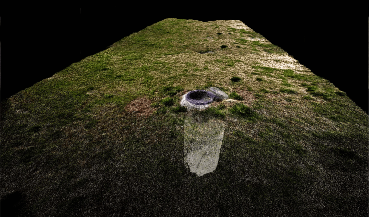
Instead of traditional survey methods—which would have required time-consuming measurements and posed safety concerns, BSI’s team walked the project site with the TrueView GO in hand. The handheld LiDAR scanner, equipped with SLAM and RTK/PPK GNSS, automatically captured every detail from above ground, including internal manhole structures. The result? Faster fieldwork, no confined-space entry, and higher-quality 3D models for CAD output.


“The TrueView GO is a great tool for as-built purposes because it speeds up the process and cuts out a lot of errors that could happen using traditional methods.”


Manhole Pointcloud

The success of BSI’s sewer mapping project is no outlier. Across the AEC, surveying, and infrastructure sectors, professionals are turning to the TrueView GO for its unique combination of portability, power, and precision.

With hardware powered by Hesai XT-16 (116S) or Hesai M2X (132S) sensors, TrueView GO delivers the point density, accuracy, and field-of-view that rival much larger systems. Whether you’re mapping a commercial property, capturing utilities, or conducting as-built analysis, you can trust the data.

No GPS? No problem. The GO’s Simultaneous Localization and Mapping (SLAM) engine, enhanced with RTK/PPK GNSS, allows it to operate effectively in GPS-denied areas like urban canyons, indoors, or underground. This hybrid scanning approach guarantees loop-free, high-precision trajectories—perfect for projects that demand flexibility.

With the dedicated TrueView GO tablet, users can visualize their scans in real time as they walk the site. This dynamic scanning approach ensures full site coverage without redundant passes or missed sections. Your data is visualized, colorized, and georeferenced on the spot.

TV Go Software

Three integrated cameras capture visuals from multiple angles and instantly apply them to your point cloud. The result: colorized, highly contextualized data that simplifies verification and enhances final deliverables like site plans, floor plans, and digital twins.

Unlike pieced-together SLAM kits, the TrueView GO is a fully integrated package:

  • No external battery
  • No additional tablet or phone needed
  • No cables to manage in the field
Just grab it, scan, and process—it’s engineered for ease of use by both experienced surveyors and new team members alike.

ALTA surveys are all about accuracy, documentation, and defensibility. Here’s how the TrueView GO is purpose-built for the job:

High-Resolution Point Clouds
Using survey-grade LiDAR and fusion of SLAM + GNSS, the GO produces rich, reliable point clouds that meet the precision demands of ALTA documentation.

Safer Fieldwork
With the TrueView Pole Mount, surveyors can safely scan storm drains, sewers, and hard-to-reach utilities—without entering confined spaces or risking exposure.

Rapid Field Collection
No need to set up tripods or worry about LOS with base stations. TrueView GO reduces field time dramatically, scanning entire sites in minutes—not hours.

Users processing pointcloud data in LP360 Land

Once your data is collected, process it using LP360 Land, the industry’s most robust software for handheld SLAM data:

  • Visualize in 2D, 3D, Profile, and Immersive modes
  • Perform QA/QC with custom issue lists
  • Export to CAD, BIM, or GIS formats
  • Create floorplans, contours, surface models, or volumetrics

LP360 makes it simple to combine data from aerial drones, terrestrial scanners, or mobile systems—allowing you to create seamless digital twins that represent both interior and exterior spaces.

Manhole point cloud in LP360

In today’s digital design and infrastructure workflows, more clients are demanding Reality Capture—complete digital representations of real-world environments. TrueView GO rises to the challenge.
Whether you’re mapping a commercial site for redevelopment, capturing utilities for design, or conducting pre-construction documentation, GO makes it easy to build a Digital Twin of your project with:


  • Precise geometry
  • Accurate imagery
  • Real-time field visualization
  • Seamless indoor/outdoor merging


With SLAM-based positioning, you can even scan interior spaces without GNSS and later merge that data with aerial drone scans for full context.

Looking to go further (or lower)? GeoCue offers purpose-built accessories to extend the value of your TrueView GO:


  • Suction Mount – Attach the GO to a golf cart or UTV to scan large areas like campuses or parking lots quickly.
  • Pole Mount – Safely scan sewer inverts, overhead piping, or under bridges—all without putting your team at risk.


These tools help transform TrueView GO into a multipurpose mobile scanning platform, whether you’re on foot, in a vehicle, or extending into difficult spaces.

User with Trueview Go

Starting at just $25,550, the TrueView GO offers unmatched performance for its price. It pays for itself after just a few projects and opens the door to new service offerings—from interior mapping and forensics to construction verification and underground inspection.

And with GeoCue’s reliable support and global customer base in North America, Brazil, and Europe, you’re backed by a partner who knows surveying inside and out.

Whether you’re conducting ALTA surveys, documenting utilities, or capturing as-built conditions, TrueView GO brings unmatched efficiency, safety, and flexibility to your work. Don’t let traditional tools limit your capabilities. With TrueView GO, you can walk, scan, and deliver—better and faster.


Talk to a GeoCue LiDAR expert today to schedule a demo or request a quote.
 Learn how easy it is to integrate SLAM scanning and Reality Capture into your surveying workflow.